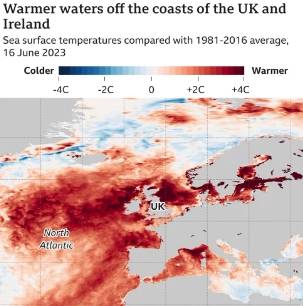
According to the European Space Agency (ESA), the seas around the UK and Ireland have experienced some of the most significant rises in marine heat globally.
Analysis conducted by the European Space Agency (ESA) and the Met Office reveals that water temperatures in certain areas are currently 3 to 4 degrees Celsius above the average for this time of year. Specifically, the sea off the east coast of the UK, spanning from Durham to Aberdeen, and off the north-west coast of Ireland, is notably warm.
According to the Met Office, the increasing temperatures are partly attributed to human-caused climate change. However, there are also other factors, both natural and man-made, that contribute to the rising temperatures, although their exact mechanisms are not yet fully understood. Scientists caution that such intense heat can have devastating effects on marine ecosystems, leading to the mass mortality of fish and other sea life.
Marine heatwaves, characterized by prolonged periods of abnormally high sea surface temperatures, not only impact the oceans but also influence weather patterns. The increased energy in the warm sea can intensify and prolong storm systems, leading to more extreme weather events. The warming of the seas around the UK aligns with the global trend of rising air and ocean surface temperatures observed in recent months.

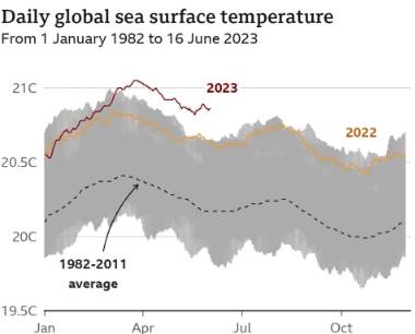
According to the Met Office’s historical data dating back to 1850, global sea surface temperatures reached record highs in both April and May. In May, the average ocean temperature was found to be 0.85C above the normal for that month, as reported by the US National Ocean and Atmospheric Administration (NOAA). These findings highlight the ongoing trend of increasing ocean temperatures on a global scale.
Recent extreme heat events have swept across the globe, contributing to unprecedented wildfires in Canada that caused smoke to engulf cities like New York. Asia has also experienced its share of record-breaking heat, with China witnessing monthly temperature records being shattered. In addition, the Antarctic has seen a concerning decline in sea ice extent, reaching a record low for this time of year by a significant margin. These occurrences highlight the far-reaching impacts of rising temperatures and climate change.

Professor Albert Klein Tank, leading the Met Office’s Hadley climate research center, holds the view that the multitude of global temperature records does not necessarily indicate that the Earth has reached a critical climate tipping point.
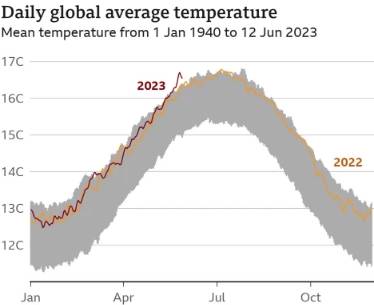
According to Professor Albert Klein Tank, the elevated sea-surface temperatures observed are a result of various natural variations within the climate system converging. These unusually high temperatures have persisted into the current month. Recent data from the EU’s Copernicus climate and weather monitoring service revealed that the first 11 days of June were the hottest ever recorded globally for this time of year.
The EU’s Copernicus climate and weather monitoring service reported that global air temperatures in June have now surpassed pre-industrial levels by more than 1.5C for the first time. Scientists agree that it is crucial to keep long-term global temperatures below this 1.5C threshold to prevent the most severe consequences of climate change.

While the current high temperatures are projected to be temporary, it is important to note that the 1.5C threshold pertains to average temperatures over a span of 20 or 30 years. Nevertheless, experts anticipate that additional temperature records will be surpassed in the upcoming months due to the expected warming of the Pacific Ocean, attributed to the emergence of an El Niño event.
Climate scientists have already made predictions indicating that 2024 is likely to become the hottest year globally. El Niño, known as the most potent climate fluctuation worldwide, plays a significant role in this phenomenon. The El Niño Southern Oscillation (ENSO), as it is scientifically referred to, is entering its warm phase, causing the emergence of warm surface waters off the South American coast. These warm waters then disperse across the ocean, generating substantial heat that influences the atmosphere.

However, the most striking rise in sea surface temperature is currently observed in the North Atlantic region. In May, temperatures reached a deviation of 1.25C above the long-term average, marking the highest recorded deviation for a single month, as reported by the Met Office.
The scientific community remains uncertain about the exact causes behind the record-breaking heat observed in the waters surrounding the UK and the North Atlantic. However, they emphasize that climate change is undeniably a significant contributing factor. The continuous release of large amounts of carbon dioxide into the atmosphere is leading to a rise in global temperatures. While climate change plays a crucial role, scientists believe that other factors are also likely influencing the situation.

According to Professor Michael Mann, an atmospheric scientist at Penn State University, the presence of less dust from the Sahara Desert in the atmosphere has been observed due to weaker than average winds. The absence of Saharan dust affects the balance of energy in the atmosphere by reducing the amount of sunlight reflected and blocked, thus allowing sea temperatures to rise without moderation.
This year, the trade winds have been exceptionally calm, and there has been a persistent weather pattern with easterly winds from the continental US, both of which may have contributed to the warming of the sea surface. Additionally, a reduction in pollution from shipping could be another contributing factor. In 2020, the International Maritime Organization (IMO) implemented regulations to reduce the sulphur content in ship fuel, which may have had an impact on the overall pollution levels and subsequent sea surface temperatures.

According to the IMO, the regulations have resulted in a significant reduction in the release of aerosol particles into the atmosphere. However, it is important to note that these aerosols also have the ability to reflect heat back into space. With their removal, it is possible that more heat has been absorbed by the waters instead. The effects of these exceptional temperatures in the North Atlantic are already starting to manifest, highlighting the significance of these changes.
The primary area where North Atlantic hurricanes originate is the eastern tropical Atlantic. The Met Office has indicated that there is a possibility of an Atlantic tropical storm forming east of the Caribbean by the middle of this week. According to Julian Heming, an expert on tropical cyclones at the Met Office, it is highly uncommon to observe a storm developing in that particular region this early in the season.
Typically, El Niño periods tend to suppress the development of hurricanes. However, the Met Office’s forecast indicates an above-average season for tropical storms and cyclones in the North Atlantic basin this year due to the elevated surface temperatures. According to the Met Office, we can anticipate the continuation of hot weather. They also state that there is a significantly higher-than-usual 45% chance of the UK experiencing a “hot summer”.


